
“Are We There Yet?”: Solving the Los Angeles Congestion Indigestion
Los Angeles has one of the world’s worst traffic congestion problems. In an effort to alleviate the “car-mageddon”, the City has started to digitize traffic patterns through partnerships with various information systems companies.
Living in Los Angeles requires one simple understanding: Traffic is always an acceptable excuse for being late.
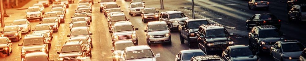
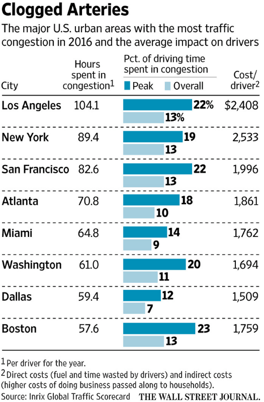
It should come as no surprise that Los Angeles (“the City”) has one of the world’s worst traffic congestion problems. Sixty-seven percent of the city’s inhabitants commute by car, the highest percentage compared to any other city in the United States.1 On average, Angelenos waste 104 hours of their life per year stuck in traffic jams. But the repercussions span beyond simply frustration at wasted idle time and never-ending queues. Traffic jams cost the City of Los Angeles a whopping $23.3 billion dollars – on an annual basis. 2 According to the 2015 Urban Mobility Scorecard, this has meant 195 million gallons of excessive fuel and 622 million hours of delay for the City. 3 As the problem worsens with a rising population, the public sector has begun to explore opportunities to digitize multiple layers of urban transportation planning, providing increased visibility into demand for roads and the ability to optimize routes, leading to decreased congestion, wait times, and costs.
Los Angeles has developed several approaches to addressing the pervasive “car-mageddon” problem. Most recently, the City has engaged in public-private partnerships with information systems companies to monitor traffic patterns.
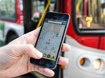
- Waze Partnership: In April 2015, Mayor Eric Garcetti announced a partnership with Waze, an app used to navigate and avoid traffic along routes. The two-way partnership dictates that Waze will provide the City with user-generated reports on traffic accidents and road obstructions. In return, the City has promised to provide Waze with information regarding road closure and construction projects so that commuters can efficiently use the app to reroute travel and alleviate congestion in certain areas. 4
- Inrix Analytics: In October 2017, the Los Angeles Department of Transportation (“LADOT”) selected Inrix Roadway Analytics, a cloud-based traffic analysis tool, to help the City analyze and access on-demand data on traffic patterns. A key feature provided by Inrix is Bottleneck Ranking, a system that identifies congested areas and then ranks the area along occurrences, length of congestion, and duration of each bottleneck. The system also allows urban planners to adjust the location of construction zones to allow for better flow of traffic.5

The Microtransit System
While information systems allow the City to make short-term informed decisions, Los Angeles has longer-term aspirations to physically alter its public infrastructure to alleviate traffic with the help of digitization. The Los Angeles Metro recently announced plans to bring in a system called MicroTransit to augment its bus and train transportation. Unlike a traditional bus, the Microtransit is a smaller
 vehicle that will follow a navigation system based on consumer demand. It “uses live traffic information and real-time requests for pick-ups and drop-offs” to optimize routes for Metro riders. Unlike Uber or Lyft, the Microtransit is expected to be integrated to the public infrastructure at much lower costs, making it accessible to a broader range of commuters. The technology will be tested first in small areas as a pilot before a comprehensive rollout. Los Angeles is not the only city to use Microtransit as other pilot cities have included San Francisco, and Santa Clara. 6
So what’s next for Los Angeles?
Integrating information analytics and augmenting public transportation is just the tip of the iceberg. Although these solutions optimize routes and alleviate traffic congestion and commute, they may not serve as strong enough incentives for Angelenos to give up driving their collective 4.5 million cars. 7 The digitization of transportation should be coupled with strong disincentive systems for commuters in order to lower the overall demand for driving.
The City should think about employing what experts call the “congestion pricing” model in order to reduce the costs associated with building more roads and parking lots to accommodate the increase in cars. 8 Tolls would be implemented on an increasing number of roads and fluctuate based on real-time information on demand for lane usage. The congestion pricing could then be integrated with Google or Apple Maps. Rather than opening up a map that shows whether leaving earlier or later would save 15 minutes, the map would show how leaving earlier or later would save the commuter $15. Putting a notional dollar amount to equate the cost of adding to the traffic congestion may make drivers think twice before picking up their car keys.
Some questions remain beyond the current and future adoption of digital systems for traffic control:
- Do the use of information systems programs such as Waze and Inrix simply reroute existing traffic to other roads in a phenomenon called “cut-through traffic” without solving the underlying issue? 9
- How receptive would Angelenos be to adopting the “congestion pricing model”? How would the City convince taxpayers to implement such a system?
(Word Count 790)
Resources
[1] 50% Rise in Gridlock Costs by 2030. Centre for Economics and Business Research. 2014. https://cebr.com/reports/the-future-economic-and-environmental-costs-of-gridlock. Accessed November 14, 2017.
[2] Cramton, Peter and R.R. Geddes. “How Technology Can Eliminate Traffic Congestion.” The Wall Street Journal, June 20, 2017. https://www.wsj.com/articles/how-technology-can-eliminate-traffic-congestion-1498010580.
[3] Shrank, David, Bill Eisele, Tim Lomax, and Jim Bak. “2015 Urban Mobility Scorecard.” Texas A&M Transportation Institute, 2015, ABI/INFORM via ProQuest, accessed November 2017.
[4] City of Los Angeles. “Mayor Garcetti Details Agreement with Waze to Help Reduce Congestion, Increase Safety, and Improve Driving Experience Around L.A.” press release, April 21, 2015. City of LA website, https://www.lamayor.org/mayor-garcetti-details-agreement-waze-help-reduce-congestion-increase-safety-and-improve-driving, accessed November 2017.
[5] Inrix. “Los Angeles Department of Transportation Selects INRIX for Urban Mobility Intelligence.” press release, October 30, 2017. Inrix website, http://inrix.com/press-releases/ladot, accessed November 2017.
[6] Huang, Emma. “Q&A: Demystifying Metro’s future MicroTransit service.” The Source Transportation News & Views, October 9, 2017. http://thesource.metro.net/2017/10/09/qa-demystifying-metros-future-microtransit-service, accessed November 2017.
[7] 50% Rise in Gridlock Costs by 2030. Centre for Economics and Business Research. 2014. https://cebr.com/reports/the-future-economic-and-environmental-costs-of-gridlock. Accessed November 2017.
[8] Cramton, Peter and R.R. Geddes. “How Technology Can Eliminate Traffic Congestion.” The Wall Street Journal, June 20, 2017. https://www.wsj.com/articles/how-technology-can-eliminate-traffic-congestion-1498010580.
[9] Bayen, Alexander, and Teddy Forscher. “Spatio-temporal road charge: a potential remedy for increasing local streets congestion.” Policy Briefs, 2017(04). ABI/INFORM via ProQuest, accessed November 2017.
As a native Californian, I can attest to Cindy’s description of traffic. I think the Waze partnership and other initiatives are a step in the right direction, but it seems that congestion pricing and public transportation are the only long-term ways to reduce traffic. The issue is that both are very politically unpopular, particularly in a community where driving is so ingrained as a part of life.
The other solution to this issue is autonomous vehicles. It is encouraging to see that California is trying to pave the way (pun intended) for the technology to take hold. Hopefully Los Angeles does the same.
Great post! I agree with considering congestion pricing. Los Angeles could leverage Virginia’s experience with congestion pricing as a potential model – Virginia partnered with Transurban, an Australian-based company, to implement this outside of Washington D.C.[1] In exchange for building and maintaining new lanes on the highway, Transurban receives toll fees less some amount that is dedicated to public transit improvements.[2] I think this type of approach may increase the receptiveness of the public to congestion pricing as there is a corresponding increase in capacity.
That said, I think there are potential concerns with this approach. Because a company is in charge of the tolls and not the government, the company may have an incentive to maximize profit over maximizing social good. For example, it may be profit-maximizing to have a higher price and lower number of cars on the new highway lanes, but traffic flow would be more optimized at a lower price with a higher number of cars. Having driven on these highways, I think this is a real issue – I recall days where the new toll lanes were priced at $15+ and only had a small number of cars on them, while the regular lanes were stop-and-go traffic; at a lower toll price point, traffic flow might have been better optimized on both sets of lanes. If Los Angeles were to pursue this course, they should consider retaining some control over pricing or better aligning incentives to maximize social good.
[1] Martin Di Caro, “Virginia Plans More High-Occupancy Toll Lanes To Ease Suburban D.C. Congestion,” February 28, 2017, https://wamu.org/story/17/02/28/virginia-plans-high-occupancy-toll-lanes-ease-suburban-d-c-congestion/, accessed December 2017.
[2] Martin Di Caro, “Virginia Plans More High-Occupancy Toll Lanes To Ease Suburban D.C. Congestion,” February 28, 2017, https://wamu.org/story/17/02/28/virginia-plans-high-occupancy-toll-lanes-ease-suburban-d-c-congestion/, accessed December 2017.
This is a very interesting application of how digital initiatives can improve a very tangible issue that the people of Los Angeles face daily. I would have never of thought of this application, even as a devoted Waze user!
I agree with Cindy and Jeff that the digital initiatives are only a way to diffuse the issue and aren’t a long-term solution to this problem. A re-work of Los Angeles’ infrastructure is the only real fix here, one that Los Angeles residents have been demanding for a while, and is likely not coming any time soon. I wonder though if the city can use the data it receives from the digital partnerships to identify and make infrastructure improvements in the most heavily congested areas of the city. I would think that targeted improvements in critical areas could go a long way to fighting the Los Angeles traffic monster.
Good to see the city of LA is finally doing something about what is probably the worst traffic congestion in the developed world – I may now consider actually moving there after school! I completely agree that there should be much stronger disincentives for commuters to drive through initiatives such as congestion pricing, which has worked well in London. However, I think in a city like LA with scant public transport infrastructure, it could place an undue burden on those in lower socio-economic brackets who will face no alternative but to pay the congestion taxes in order to commute to and from work every day.
I also wonder whether some of these initiatives are merely incremental, short-term improvements rather than longer-term solutions. It would be great if after a century of being amongst the worst offenders for adapting to the rise of the car, LA could lead the way in the 21st century by implementing innovative solutions encompassing the next big technological revolutions in transport, such as autonomous vehicles, electric cars, and ride sharing.