
Unlocking the Power of Open Innovation in Disaster Relief
How the International Federation of Red Cross is Tapping into the Universal Desire for Purpose & Connection Through Crowdsourcing
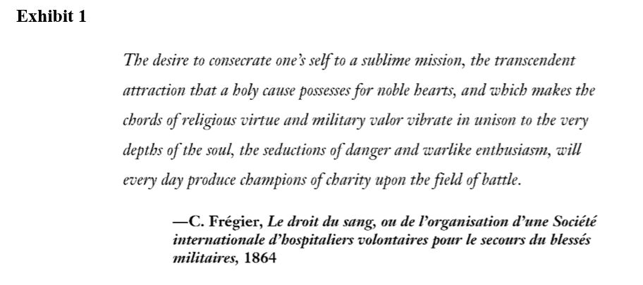
Exhibit 1 [1] describes an innate human desire for purpose, connection, and the ability to contribute to something bigger than oneself. The International Federation of Red Cross and Red Crescent Societies (IFRC) [2] has been tapping into this universal desire for purpose since 1863. This report aims to outline how the IFRC employs a crowdsourcing approach to the curation of crisis maps during disaster relief operations, as well as some of the coordination challenges and opportunities associated with such endeavors.
Harnessing the Power of Crowds at IFRC
A primary objective of the IFRC is the prevention and alleviation of human suffering [3]. One of the ways the IFRC contributes to this objective is through disaster preparedness and response initiatives. In the immediate aftermath of a crisis, the IFRC must answer three key questions: (1) where were people during the disaster, (2) how many people are affected, and (3) what are their primary needs. [4] Considering the IFRC must always be prepared to quickly and accurately answer these questions for disasters in any country and that it is a non-profit organization with few fulltime employees, human capital is a constraint in the disaster relief data acquisition process. Moreover, some of the world’s most vulnerable people live in communities that are not visible on digital maps, exacerbating the difficulties associated with answering the aforementioned critical questions. [5]
Crisis Mapping
To gather information regarding the damage associated with a disaster, the whereabouts of victims, and current risks that are missing from digital maps, the Red Cross, Humanitarian OpenStreetMap Team, and Doctors Without Borders founded an organization to support the curation of crisis maps. [6] Since 2014 over 63,346 volunteers have made 42,503,857 edits to Missing Maps, an open, collaborative project in which volunteers map areas where humanitarian organisations are trying to meet the needs of vulnerable people. [7] Exhibit 2 outlines how data is collected from volunteers through open innovation.[1]

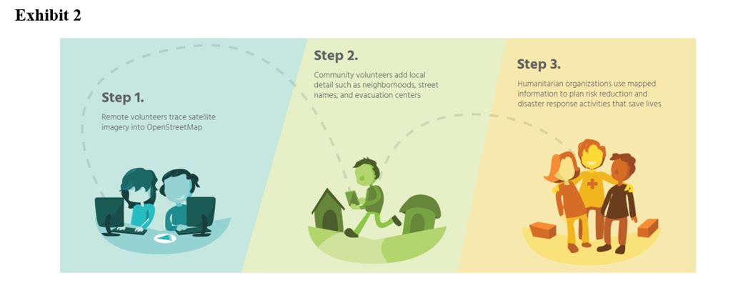
Open innovation also allows the IFRC to acquire data immediately after a disaster via social media, and victims can geo-tag various requests for resources which helps the IFRC visualize where resources need to go and bucket the various requests into categories, such as medical, food, or trapped people. Exhibit 3 provides an illustration of food requests on a Ushahidi[2] crisis map after the Haitian earthquake. [8]
Challenges & Recommendations
When speaking with first responders, one learns that “by far, the number one challenge in responding to any crisis is communication and coordination among the various agencies responding to the crisis. It is one of the most critical elements and one of the hardest to get right.” [9] A National Guardsman who responded to hurricane Harvey also echoed this sentiment, stating: “it’s great to get a lot of engagement from folks on the ground but sometimes we receive too much data to decipher and synthetize quickly into action plans, let alone coordinate with other responders.” [10]
For open innovation to be more effective at the IFRC, it must apply the participatory data collection approach to not only those requesting resources, but also those providing resources. Exhibit 4 shows why an interagency map [11] in an essential mechanism for connecting victims with resources.
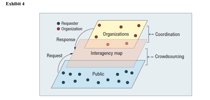
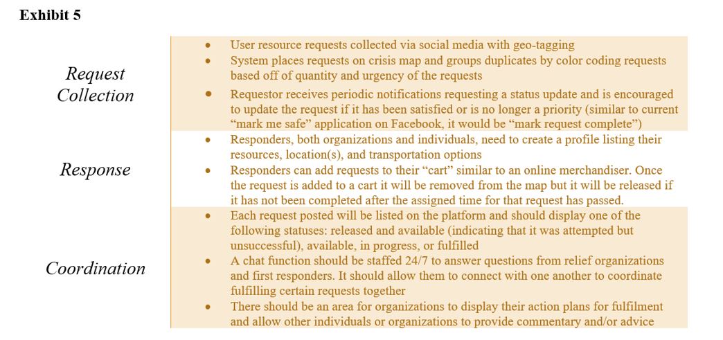
Similar to US military operations & intelligence [12] team structures, data collected from individuals and organizations on the ground needs to be collected and synthetized by a centralized unit and then matched with the organizations that have the required resources to meet those requests. The IFRC needs to take ownership of this interagency map and ensure it provides the features listed in Exhibit 5 [13].
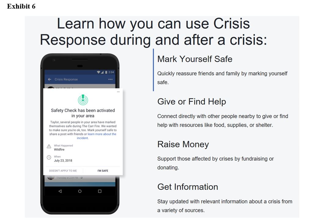
It is recommended that the IFRC leverage its partners, specifically Facebook, for the execution of this map. Facebook is a viable host for the interagency map because the map must be on a platform that is open to the public and intuitive to the user. Fortunately, the IFRC has already begun a partnership with Facebook by utilizing population maps which help determine where communities are located after a disaster [14]. Moreover, Facebook has implemented a limited version of the interagency map concept by attempting to provide a central location for individuals to provide and request support, as seen on their website in Exhibit 6 [15]. The IFRC should work with Facebook, governments, and organizations to bolster this platform. Subsequently, the IFRC and its partners should formalize and market the interagency map so that all responders and governments are aware of the platform.
Open Question
While open innovation has tremendously benefit disaster relief and has lots of potential for further impact, not all individuals who have access to public crisis maps are well intended. Some nefarious groups may utilize crisis map information to target relief workers or lure responders into dangerous situations with fake requests. [16] How can the IFRC validate the legitimacy and intent of requests to protect their volunteers without limiting public access to this critical information?
[1] The IFRC and its partners also host mapathons—often with academic institutions—around the world, where volunteers collect information such as water points, medical facilities, and pieces of land that are prone to erosion.
[2] Ushahidi is another open source platform that leverages Web 2.0 technologies to integrate data from a variety of sources, including phones, social media, and email to provide crisis maps to relief organizations and the general public.
Word Count: 798
Sources
[1] Hutchinson F. John, Champions of Charity, War and the Rise of the Red Cross (New York, NY: Routledge Taylor & Francis Group 1996)
[2] Daniel Palmieri, “How warfare has evolved –a humanitarian organization’s perception: The case of the ICRC, 1963-1960” Historical Research Officer at the International Committee of the Red Cross (ICRC), 2015, pg. 985
[3] Wiem Chamsi, “A short way to explain the Red Cross Red Crescent Movement and my National Society”, International Federation of Red Cross and Red Crescent Societies, April 3, 2017 https://media.ifrc.org/innovation/2017/04/03/all-you-need-to-know-about-the-red-cross-red-crescent-movement/, accessed November 2018.
[4] Red Cross, “Data: A vital tool for disaster response,” https://www.redcross.org/about-us/news-and-events/news/Data-A-vital-tool-for-disaster-response.html, accessed November 2018
[5] Huiji Gao and Geoffrey Barbier, Arizona State University, Rebecca Goolsby, US Office of Naval Research, “Harnessing the Crowdsourcing Power of Social Media for Disaster Relief,” Cyber-Physical-Social Systems,http://startides.net/sites/default/files/documents/files/Harnessing-the-Crowdsourcins-Power-of-Social-Media-for-Disaster-Relief.pdf , accessed November 2018.
[6] Missing Maps Organization, “About,” http://www.missingmaps.org/, accessed Novembre 2018.
[7] Missing Maps Organization, “How we work,” http://www.missingmaps.org/, accessed Novembre 2018.
[8] Huiji Gao and Geoffrey Barbier, Arizona State University, Rebecca Goolsby, US Office of Naval Research, “Harnessing the Crowdsourcing Power of Social Media for Disaster Relief,” Cyber-Physical-Social Systems,http://startides.net/sites/default/files/documents/files/Harnessing-the-Crowdsourcins-Power-of-Social-Media-for-Disaster-Relief.pdf , accessed November 2018.
[9] Interview with Dr. David Barash, Emergency Relief Physician, Chief Medical Officer of the GE Foundation, November 11th, 2018.
[10] Interview with SFC, Special Forces Weapons Sgt., Texas National Guardsman, November 10th, 2018.
[11] Huiji Gao and Geoffrey Barbier, Arizona State University, Rebecca Goolsby, US Office of Naval Research, “Harnessing the Crowdsourcing Power of Social Media for Disaster Relief,” Cyber-Physical-Social Systems,http://startides.net/sites/default/files/documents/files/Harnessing-the-Crowdsourcins-Power-of-Social-Media-for-Disaster-Relief.pdf , accessed November 2018.
[12] Interview with Former Captain, US Army, Troop commander (Afghanistan and Middle East), November 8th, 2018.
[13] Huan Liu, Geoffrey Barbier, and Gao Huiji, “Promoting Coordination for Disaster Relief –From Crowdsourcing to Coordination,” Computer Science and Engineering Arizona State University Working Paper, accessed November 10th 2018.
[14] Facebook research, “network coverage, power, and displacement,” https://research.fb.com/new-data-tools-for-relief-organizations-network-coverage-power-and-displacement/, accessed November 7th 2018.
[15] Facebook, “Crisis Response, https://www.facebook.com/about/crisisresponse/ , accessed November 7th 2018.
[16] Woodrow Wilson International Center for Scholars, “Liability & Reliability with Crowdsourced & Volunteered Information for Disaster Relief,” Domestic Emergency Presentation, August 30th 2011.
Kaleigh, you presented an outstanding use case for open innovation. I really like what you highlighted in exhibit 2 about utilizing both remote and local sources. Your open question is the biggest challenge I see for the IFRC moving forward. The data being collected is extremely powerful and I fear that it could be used by business who will use predatory pricing to gouge those in need after a disaster. I am very curious about how the Red Cross will handle this challenge moving forward.
You are spot on in your question – is it possible for the IFRC to make a system that is sufficiently accessible to be broadly useful but capable of identifying and filtering false or erroneous requests? The military often uses satellite imagery or drones to corroborate intelligence reports – perhaps a similar approach could be used to gather more information about unusual/suspicious aid requests (either in cooperation with the military for larger disasters or using smaller commercial drones at the agency/group level)? Additionally, there may be an opportunity for enhancing coordination between responders with a kind of “tactical overlay” package only available to recognized relief agencies that uses geotagging to show the exact location of relief assets relative to the resource requests. This could facilitate effective and efficient coverage of a geographic area between several different agencies or response groups.
Kaleigh, amazing article. I agree with Baker’s concerns, and I would add another aspect to them. Several of the areas that these organizations operate are in countries with unstable or corrupt governments. The anonymity of the people of that region, in some cases, may be warranted to protect those people. As an example, I have a friend in Uganda that runs a ministry whose location she intentionally keeps secret. She has several children and teen mothers at her site, and requires armed guards to ensure their safety. I would consider keeping this platform closed to the public and only allow access by organizations with proven track records before we open it up for broader use. In the same way the former Army Captain eluded to, it’s imperative that this intelligence gets passed to highly competent and capable organizations such as the Navy to ensure the mission is accomplished efficiently and effectively.
Your example of disaster relief is one of the strongest examples of open innovation being used for good. It’s a compelling cause that the social media companies you listed could do more to help. I agree with your points around preparation and response to disasters. While the information is hard for the IFRC to control, they could share more best practices and training to help responders and contributors give more timely, relevant information in crisis situations. The question about balancing information availability and public access is tough. Perhaps there could be automated technology to help, for instance, take sensitive information offline. Thank you for sharing these thoughts, looking forward to following how this space develops!
Great post Kaleigh and interesting comments Cathy. While it can be difficult synthesize crowd sourced information, I have to imagine there are ways that data aggregation can be standardized and streamlined.
I love this post and feel that the potential here is huge. Not only can you get a much more accurate and dynamic understanding of needs, but there are huge advantages to having coordination across various relief organizations which will allow for specialization and minimize costly and unfortunate duplication. To answer your question – I think organizations like the Red Cross can sort inputs in a couple of ways that would minimize risks. First, by volume. If they have a large number of requests in a certain area, they can have a certain level of confidence that it is accurate and not nefarious. Second, I wonder if they could develop a system over time where individuals become trusted contributors overtime leading to a certain “accreditation” which would allow the organizations to know how much caution may be necessary with any individuals request. Just some starting points! Great article and a fascinating application to do tremendous good!
Agree with the other commenters about what a compelling application of the technology this is, and equally agree with the concern you raise about unintended consequences- particularly given the acute vulnerability of this context. I think you do a great job articulating the role of crowdsourced data and mapping in coordination of delivery, and I wonder what it would take on the side of the intervening organizations (UN, ngos, military, government, etc) to use the platform effectively and dynamically to ensure that they don’t compound the issue of duplication and gaps by all looking at a map and rushing to where the gap in coverage is.
On another note, something that I always found particularly compelling about the use of crowdsourcing by crisis mappers was the concept of all of the volunteers who were able to contribute regardless of where in the world they were or how little or fragmented their available time may have been. I was struck by this format of sort of… micro- and remote volunteering, and with a skillset that we don’t traditionally associate with relief work. It lowered and moved the “bar” for contributing to disaster relief in a way that I think has such huge lessons for other fields. What if when we stood in line at spangler, instead of scrolling through instagram, we could hop on a crowdsource platform with a mission and spend those minutes chipping away at a problem?