
The power of GIS for UNCHR – visualizing supply chains
Geographics Information System (GIS) tools can visualise and organise UNHCR's supply chains around the world.
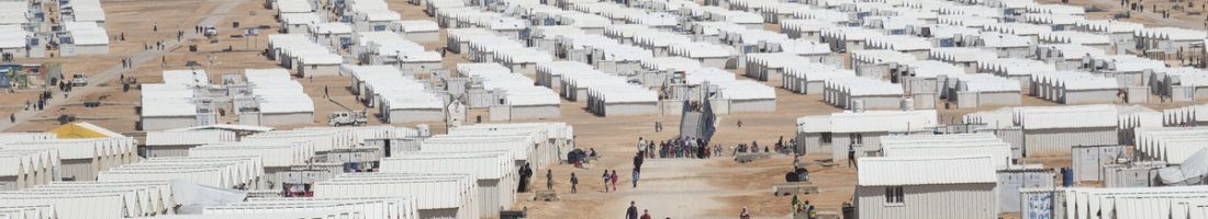
Imagine a hotel complex. Next, transform hotel rooms into metal containers, scatter them out on a desert plain . Surround everything with a fence. Welcome to a UNHCR refugee camp. Every day, hundreds of new refugees are admitted to this camp. In a hotel, you would have to distribute rooms. In a refugee camp in Jordan, you have to allocate access to metal containers. Since excel sheets are the only tool you can use, your team becomes the bottleneck of the camp’s supply chain. What can you do?
Yahya Hassune from Jordan encountered this challenge when he worked for United Nations High Commissioner for Refugees (UNHCR), the refugee agency of the United Nations. He decided to map out shelter allocation in Azraq refugee camp using Geographic Information System (GIS) software, a tool that enables users to organise layers of data on maps. The initiative was highly successful. Container allocation could be handled much faster, while it became possible to visualize information on the number of tenants and the conditions of containers.[1]
Azraq camp is currently home to 53,254 people[2], less than 0.01% of the 65.6 million globally displaced people.[3] Humanity never recorded more displaced persons than it does right now.[4] Refugee camps essentially have to be operated like little cities requiring excellent supply chain management. Beyond refugee camps, displaced people find shelter in local host communities that are even more difficult to reach and to supply than camps. The example of GIS usage in Azraq shows that UNHCR can dramatically increase efficiency by utilizing simple GIS tools.
UNHCR usage history of GIS dates back to 1998.[5] The agency Pitney Bowes MapInfo mapped out existing refugee camps. By 2005, a formal GIS structure was established.[6] This approach allowed map creation to ease strategic decisions. On an operational level, however, GIS tools still have a lot of potential. Unfortunately, development of GIS utilization in developing countries is still in its infancy. [7] [8] Applications are developed without overarching plans for transnational integration.
Another successful UNHCR GIS application empowers refugees. The project RefuGIS was implemented in the Zaatari camp in Jordan. There, refugees have to deal with shortages of water, food and medical supply. RefuGIS was introduced through a training facility. It was the “first project wherein refugees are wholly involved in community decision-making processes, from emergency planning to infrastructure classification. By employing their newly acquired GIS skills, participants in RefuGIS can create the maps that support discussions about camp management and community engagement.”[9]

The project was enabled by UNHCR Innovation Service. The team around this program was set up to capture, develop and communicate innovation.[10] UNHCR lines out in its Strategic decisions 2017-2021, that it will “carry out an urgently needed simplification and streamlining of procedures, processes and tools, including in key areas of program, procurement, supply, and administration.”[11] The organisation is aware that it needs to update its supply chain management, ideally through innovation from within.
Access to high-quality information remains vital for effective aid as crises in developing countries currently continue to unfold. One application UNHCR can focus on, is fuzzy analytic hierarchy process (FAHP). This process is essentially a spatial algorithm that allows organisations to address multiple criteria, such as social, geographical and other contributing factors, to manage supplies in UNHCR camps.[12] Traditional GIS applications are based on a Boolean approach that only allows to use data based on classifications as true or false. FAHP works with data that can be based on further criteria, providing more options in mapping processes.
Further potential GIS applications to improve supply chain management are not limited to short-term crisis response situations. UNHCR frequently needs to develop plans to deal with the transition of emergency response plans into long-term strategies. A critical aspect is reconnection of urban areas to national supply chain interdependent critical infrastructure systems (SCICI). GIS applications are needed to make SCICI visible and understandable.[13]
Organising data on maps through GIS tools is one aspect of the megatrend digitalisation. UNHCR has many operations in developing countries where data collection and organisation are still in the pipeline. Going forward, UNHCR should try to foster and lead change in its supply chain management through the usage of GIS tools.
My questions:
Can you think of examples how UNHCR, a large international organization with many bureaucratic layers, could foster and spread innovative applications of GIS?
How can refugees and UNHCR use GIS tools to manage supply chains together?
(733 words)
Photo credits: Chris Herwig/Norwegian Refugee Council
[1] UNHCR Innovation, Using GIS technology to map shelter allocation in Azraq refugee camp, http://www.unhcr.org/innovation/using-gis-technology-map-shelter-allocation-azraq-refugee-camp/, accessed November 2017
[2] UNHCR Syria Regional Refugee Response, http://data.unhcr.org/syrianrefugees/settlement.php?id=251&country=1, accessed November 2017
[3] 2015 Global Migration Trends Factsheet, IOM’s Global Migration Data Analysis Centre GMDAC, http://gmdac.iom.int/global-migration-trends-factsheet, accessed November 2017
[4] UNHCR, Figures at a Glance, http://www.unhcr.org/en-us/figures-at-a-glance.html, accessed November 2017
[5] December/January 2007-08 | GEOconnexion International Magazine, p.45
[6] UNHCR, GIS Experts and UNHCR Structure, http://www.unhcr.org/en-us/publications/maps/441688bc0/gis-experts-unhcr-structure.html, accessed November 2017
[7] Ecological Society of America, Addressing challenges of developing countries in implementing five priorities for sustainable development goals, http://onlinelibrary.wiley.com/doi/10.1890/EHS15-0028.1/full, September 29, 2015
[8] Laura Eldon, Using geographic information systems in humanitarian response – Oxfam Views & Voices, https://views-voices.oxfam.org.uk/methodology/ict4d/2017/09/geographic-information-systems-humanitarian-response, September 13, 2017
[9] GIS for Refugees, by Refugees | ArcNews, http://www.esri.com/esri-news/arcnews/summer17articles/gis-for-refugees-by-refugees, Summer 2017
[10] UNHCR Innovation Service, Year in Review 2016, http://www.unhcr.org/innovation/wp-content/uploads/2017/06/UNHCRInnovationService_YearInReview2016-1.pdf, p.27, , accessed November 2017
[11] UNHCR, UNHCR’s Strategic Decisions 2017-2021, http://www.unhcr.org/5894558d4.pdf, p.31, accessed November 2017
[12] Mark Altaweel, How Spatial Modeling Can Help with Refugee Aid, GIS Lounge, https://www.gislounge.com/spatial-modeling-can-help-refugee-aid/, November 4, 2017
[13] Ramachandran, V. et al., (2016). Post-Disaster Supply Chain Interdependent Critical Infrastructure System Restoration: A Review of Data Necessary and Available for Modeling. Data Science Journal. 15, p.1. DOI: http://doi.org/10.5334/dsj-2016-001
Very interesting take on supply chain! I think it’s interesting to abstract from your essay a bit and think of all 66 million refugees as the input to the “process”, their temporary living quarters in refugee camps as “buffers”, and their final places of residence as the “finished product” of the “machine” that is displaced people in the world. Thinking of the problem this way, you can image really powerful applications of GIS in terms of minimizing throughput time (i.e. the amount of time refugees need to spend in temporary camps), while maximizing utilization (i.e. the efficient use of temporary housing provided by the UN). Tough questions but GIS seems like a great way to tackle it quantitatively.
I appreciate you bringing up such an important topic. I agree with you that application of GIS is much more than just planning & coordination. Some of the challenges faced are in giving access to refugees on education & livelihood. While we see some progress in using these systems to understand the “demand” and match with “supply”, it may not be always possible to bring outside supplies timely. So another interesting application would be to collect and integrate the data on the refugees and use it to make those resources available to themselves as required. Eg: some of the refugees could be doctors or teachers and can be relied upon till outside supplies get in.
Very interesting take on examining benefit of digitization in crisis management. Problem of refugee camp is really close to home. Use of GIS is one application of how technology can enable crisis/disaster management in high stress environment. I strongly believe that there is space to leverage technology beyond allocation and data gathering. Social media initiated the community data gathering with features such as safety check during crisis. UNHCR should collaborate with technology players to optimize operations further. In such circumstances, improvement in “supply chain” results in saving lives.